WASHINGTON (July 29, 2025) — Anticipating a strong cross-current that never materialized, an experienced tow pilot deviated from the sailing line on the Mississippi River and struck components of the Fort Madison Bridge near Fort Madison, Iowa, the National Transportation Safety Board said Tuesday.
The
towing vessel Joe B. Wyatt was pushing 13 loaded hopper barges and 2 empty tank barges downriver on May 9, 2024, when the tow struck the bridge’s protection cell and fendering system and broke apart. No injuries or pollution were reported. Damage to the protection cell, fendering system, barges and the Joe B. Wyatt was estimated at $3.28 million.
The pilot had decades of experience maneuvering tows, including through the Fort Madison Bridge’s primary channel. Based on this experience and his anticipation of a cross-current coming from around Dutchman Island, he maneuvered the tow over 200 feet off the sailing line toward the right descending bank. The cross-current, if present at the time, did not have the effect the pilot anticipated. Because the pilot overcompensated for the anticipated cross-current, the 1,153-foot-long tow was out of position as it approached the bridge.
The pilot increased the vessel’s engine power to try to maneuver the head of the tow back toward the center of the channel. Despite his efforts, the third barge in the starboard string contacted the protection cell. The tow subsequently broke apart and 13 of the 15 barges drifted downriver.
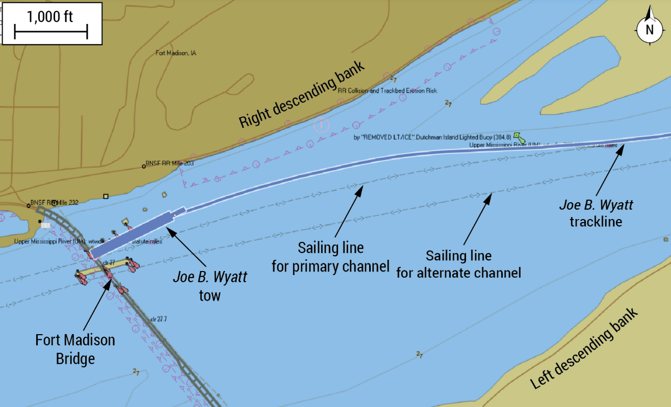
Track of the Joe B. Wyatt as it approached the Fort Madison Bridge. (Background source: National Oceanic and Atmospheric Administration Electronic Navigation Chart U37UM359 as viewed on Made Smart automatic identification system.)
“Generally, a sailing line is assigned to a known safe route used by commercial vessels,” the report said. “A sailing line is developed with consideration of channel depth, current patterns, and any other known obstructions to navigation. A charted sailing line provides for a safe and successful transit when used as a guide, along with the mariner’s own experience and assessment of the existing circumstances.”
Marine Investigation Report 25-28 is available online.
To report an incident/accident or if you are a public safety agency, please call 1-844-373-9922 or 202-314-6290 to speak to a Watch Officer at the NTSB Response Operations Center (ROC) in Washington, DC (24/7).
